
Using topo maps to guess historical land use
My post about walking
distance got me
thinking about changes in our area over time. I wanted to go back
and look at some old USGS maps, and was surprised to learn that you
can now download all of the maps from your region as pdf files for free! (The last time I
played with topo maps, about six years ago, you either had to buy a
paper copy from the USGS or snag screenshots from various websites that
were trying to sell paper maps.)
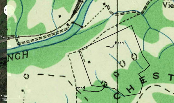
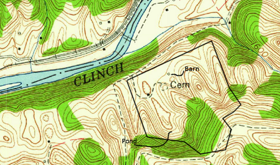
For our area, the maps
available were from 1935 (first map) and 1957 (second map), and I also
took a screenshot of google maps' current satellite photo (third map)
for a more up-to-date view. Then I layered them all together in
the Gimp. I cropped a bit of the 1935 map off and made the top
map slightly transparent in the first image in this post so you can see
what I'm talking about when I refer to layering.
The property I'm taking
a look at here is the
same potential Walden Effect annex I mapped the soil for. I was interested to
see that, except for the ridge (south end of map), the propery was
entirely devoid of trees between 1935 and 1957.
Solid black squares on a
topo map represent houses, dotted lines are small roads or trails, and
outlined squares are generally barns or other large, non-residential
structures. With that information in mind, you can see that
someone was living on the property during both 1935 and 1957, probably
grazing animals or possibly growing corn and tobacco on most of the
acreage.
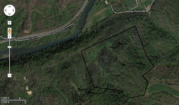
Between 1957 and the
present, the majority of folks stopped farming in our region and
started getting jobs in town. Although it's sad that people were
no longer living off the land, the earth rejoiced by sprouting up trees
everywhere. Only a few acres on the northwest side of the
property remained clear of trees by the time of the 2011 aerial photo.
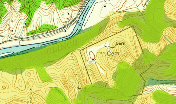
I merged all three of
these maps together to create the version above,
which gives a rough estimate of canopy cover over time. The
lightest
color is areas that are currently forested, the bright green represents
1957
trees, and the dark green is 1935 trees. (I didn't bother with
the area on the other side of the river, and you'll notice some
irregularities between 1935 and 1957 forest borders that are probably a
sampling error due to the low resolution on the earlier map.)
Why does it matter which
areas had trees in the past? It's handy to know that the woodland
is at least 77 years old on the ridgetop, because that kind of forest
will be chock full of plants and animals found in few other places and
is best left alone. On the other hand, twenty-plus years of
farming on the rest of the property may mean the topsoil has been
eroded away, and definitely means I'll feel less guilty about clearing
spots for sustainable agricultural purposes. And, of course, it's
just plain fun to guess what the land was like decades in the past.
Have you discovered even
better sources of historical maps or aerial photos online? Since
it's the weekend, I can probably sink my teeth into some more....

Or explore more posts by date or by subject.
About us: Anna Hess and Mark Hamilton spent over a decade living self-sufficiently in the mountains of Virginia before moving north to start over from scratch in the foothills of Ohio. They've experimented with permaculture, no-till gardening, trailersteading, home-based microbusinesses and much more, writing about their adventures in both blogs and books.
Want to be notified when new comments are posted on this page? Click on the RSS button after you add a comment to subscribe to the comment feed, or simply check the box beside "email replies to me" while writing your comment.
Mom --- I hope you figured out the link!
Patti --- It's true that trees come back pretty quickly, but it does take decades to regain real forest characteristics. I figure if a forest is at least thirty or forty years old, we should preserve it's momentum, and let it keep going if at all possible....
http://www.historicaerials.com/
This site may be of some help. In some areas they have a lot of the aerial photos dating back to the 50's, but other areas just include the older Topo maps.