Keylines
Although I complained earlier that Restoration Agriculture
included too much rehashing of other books, my very favorite part was
actually his explanation of water management using keylines. I've never
tracked down a copy of P.A. Yeomans' book on the subject and thus
didn't really understand the system, so I appreciated Mark Shepard's summary.
I've heard people bandy
around the term "keyline" for years, and it took me a while to realize
they weren't talking about ley lines. (Yes, my brain does
automatically turn off when I hear, or think I hear, certain
words.) I'd also read several authors writing about bringing water
from the valleys to the ridges, and I couldn't quite figure out what
they were talking about since we all know that water flows
downhill. Mark Shepard's chapter on the topic cleared up all of my
misunderstandings.
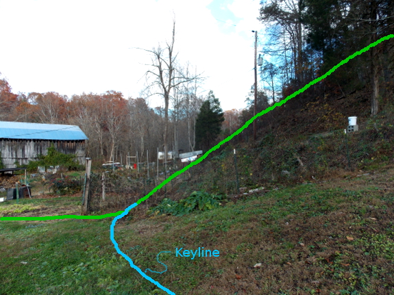
First of all, a keyline
is simply the spot on the landscape where a steep slope turns shallow,
as you can see in the photo above. The idea is that by managing
water along this line, you can move the least dirt while having a large
effect downhill.
Why do you want to have
any effect at all? I chose to photograph the hill I did because
that's the one that feeds the extremely high groundwater in our forest
garden. According to Yeomans (the originator of the keyline
concept), swampy bottomland results from mismanaging the water
upstream. To correct the problem, you dig a swale (an on-contour
ditch) along the keyline so that water doesn't whoosh right down into
the swampy bottom, but instead flows gently (along a 1% downhill slope)
to drier areas to the side. This is known as a spreader swale, and
it's what folks mean when they talk about moving water from the valleys
to the ridges --- you're not technically bringing water uphill, but you
are moving it from a wetter area to a drier area. The result is a
more productive, damper area to the side of the keyline, and a more
productive, drier area in the flat zone directly downhill.
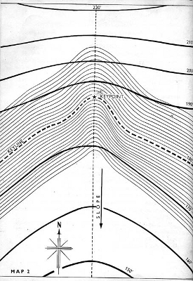
Another facet of the keyline system is pocket ponds, which are just like my sky pond,
but are located at keypoints (the center of the keyline). These
vernal pools aren't meant to stay wet all year, but they do act as surge
protectors, giving you somewhere to store excess water during wet
seasons and then disbursing that water to the surrounding area once
things dry out.
The final part of the
keyline system consists of subsoiling (running a small plow deep in the
earth) parallel to the swales each year to break up hardpan.
Similarly, you can build more swales parallel to the keyline swale and
plant trees along them, resulting in easy-to-handle rows that still work with (rather than against) your site.
Understanding keylines got me thinking that I should definitely give the
concept a try above the forest garden. I've had pretty good luck
moving trees upward into raised mounds, but wouldn't it be wonderful not
to have a swamp there each winter? Sounds like another fall
earth-moving project just waiting to be explored!
| This post is part of our Restoration Agriculture lunchtime series.
Read all of the entries: |
Or explore more posts by date or by subject.
About us: Anna Hess and Mark Hamilton spent over a decade living self-sufficiently in the mountains of Virginia before moving north to start over from scratch in the foothills of Ohio. They've experimented with permaculture, no-till gardening, trailersteading, home-based microbusinesses and much more, writing about their adventures in both blogs and books.
Want to be notified when new comments are posted on this page? Click on the RSS button after you add a comment to subscribe to the comment feed, or simply check the box beside "email replies to me" while writing your comment.
You'd have to do some pretty accurate surveying to achieve a 1% gradient.
But it can be done even with modest means. Roman aquaducts had a gradient of around 0.15-0.30%, achieved with relatively basic surveying equipment, basically a big spirit level.
A laser pointer weighted to hang horizontally might do the trick.
Whereas "contour plowing" was devised with the intent to minimize soil erosion, this seems to be similar but with intent to maximize water distribution to needed areas, thus minimizing it to the naturally low spots. Same difference, really.
As Roland points out, it doesn't take much gradient to keep water flowing and your accuracy in achieving exactly 1% isn't too important.
Agronomists tell us that American ag production could be increased by 10% if there was universal, proper use of drain tiling of fields to eliminate wet spots. Of course, you need a lower spot to divert the water to for tiles to work. I gather that's not an option for you.
Whatever the percentage of accuracy required to achieve the end goal - THIS visual you made Anna was an AWESOME tutorial for me! I could have heard about it or read about it, but your visual was an exceptionally vivid way to define how the keyline works! Very intersting Thanks!
It's fairly easy to get accurate levels (probably more accurate than a laser level) using a length of clear hose. Just attach the hose to two pegs and you have what we call a bunyip level here in Aus.
Here's a great description:
http://www.harvestingrainwater.com/wp-content/uploads/2006/05/Bunyip-Water-Levels-and-A-Frame-Levels-Appendix-2.pdf
Thanks for the summary. I was going to buy his book but after all the reviews I just decided to read your site as I already understand the framework.
On keylines though. From my understanding, the keypoint is the center of the VALLEY, and the keyline goes through that ON-CONTOUR (0 degree slope).
The rest of the lines are parallel to the keyline, which unless the valley has a perfectly consistent shape, makes all the rest of the lines off-contour with varying amounts of slope (like in the yeomans drawing).
Finally, Yeoman's books can be found here (most of them) online.
http://www.soilandhealth.org/01aglibrary/01aglibwelcome.html
and here's another good one
http://journeytoforever.org/farm_library.html