
How to map property boundaries from a deed
 Last
week, I mentioned that the
shape of your property on the tax assessor's map could be wrong. So how do you figure
out where the real boundaries are? The geekily inclined will
enjoy pulling out their deed and mapping the property boundaries
themselves.
Last
week, I mentioned that the
shape of your property on the tax assessor's map could be wrong. So how do you figure
out where the real boundaries are? The geekily inclined will
enjoy pulling out their deed and mapping the property boundaries
themselves.
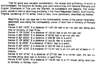
Your deed will probably
have a section a bit like the first image in this post which lists a
series of directions and distances. A rectangular property would
only have four corners, but most properties in our neck of the woods
are oddly shaped and contain ten or twenty points, which complicates
matters. I like to sum up all of the points in a spreadsheet like
the one shown below to keep myself on track.
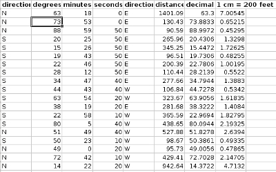 You'll notice that the first
six columns are copied directly from the deed, but where did the other
two columns come from? To calculate decimal degrees, divide the
seconds by 360, the minutes by 60, and leave the degrees alone, then add
all three numbers together for each point. I like to use a
spreadsheet rather than jotting down the numbers in a notebook since I
can set up a formula to do all the math for me.
You'll notice that the first
six columns are copied directly from the deed, but where did the other
two columns come from? To calculate decimal degrees, divide the
seconds by 360, the minutes by 60, and leave the degrees alone, then add
all three numbers together for each point. I like to use a
spreadsheet rather than jotting down the numbers in a notebook since I
can set up a formula to do all the math for me.
The last column in my
spreadsheet shows how many centimeters I'll measure on my map for each
distance, which requires me to choose a scale. After playing
around with my sheet of graph paper, I settled on 1 centimeter for 200
feet --- you might want to set 1 centimeter equal to 100 feet on a
larger property or to 50 feet on a smaller property. You can also
measure in inches, but my rulers tend to divide inches up into eighths
and centimeters into tenths, which makes it easier to deal with
decimals on the centimeber side. Again, I set up a formula in the
spreadsheet and let it do all the math for me.
 As
a side note, older deeds often list distances in poles and links.
A pole (also known as a perch or a rod) is equal to 16.5 feet and a
link is equal to 0.66 feet. Again, setting up your spreadsheet
carefully makes it easy to convert from these older measurements to
something you're more familiar with.
As
a side note, older deeds often list distances in poles and links.
A pole (also known as a perch or a rod) is equal to 16.5 feet and a
link is equal to 0.66 feet. Again, setting up your spreadsheet
carefully makes it easy to convert from these older measurements to
something you're more familiar with.
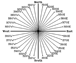
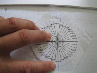
Now you're ready to
map! You'll need a sheet of paper (graph paper is better, for
reasons I'll explain tomorrow), a ruler, and a protractor. Since
I lost my tenth grade protractor somewhere or other and didn't want to
remember how to orient the protractor to deal with all the directions anyway,
I just printed out the image to the left, cut out a circle of paper
containing the protractor, and coated it with clear tape that extended
past the edges of the paper. I used my ruler to make the lines on
the protractor extend onto the transparent tape, then cut out a hole in
the center of the protractor to allow me to line the tool up
properly. Fifteen minutes later, I had the homemade protractor
shown below.
 Before you start, remember to
label north and the scale on your paper. Since the deed I was
working with mentioned that the boundaries listed start at the
northwest corner of the property, I set my first dot in a random
location in the upper left side of the paper. I set my protractor
on top of the dot (making sure north was lined up correctly), and made
a mark at what I estimate to be 63.3 degrees in the northeast quadrant.
Before you start, remember to
label north and the scale on your paper. Since the deed I was
working with mentioned that the boundaries listed start at the
northwest corner of the property, I set my first dot in a random
location in the upper left side of the paper. I set my protractor
on top of the dot (making sure north was lined up correctly), and made
a mark at what I estimate to be 63.3 degrees in the northeast quadrant.
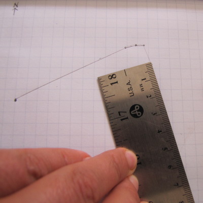 Next, line your ruler up so
that zero is at the first dot, with the ruler making a straight line
through the second dot. Plot the first distance listed in your
spreadsheet. Now, go back and mark the distance and direction for
the rest of the points in turn. (I recommend plotting your
boundaries in pencil and erasing your direction dots as you go along so
you don't get confused.)
Next, line your ruler up so
that zero is at the first dot, with the ruler making a straight line
through the second dot. Plot the first distance listed in your
spreadsheet. Now, go back and mark the distance and direction for
the rest of the points in turn. (I recommend plotting your
boundaries in pencil and erasing your direction dots as you go along so
you don't get confused.)
If you're really good,
your final line will end up hitting your first dot, but don't be too
concerned if it's a short distance off. Especially if you're
using a homemade protractor like mine, chances are you'll have to fudge
a bit at the end to make your property close up.
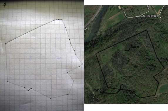
It turns out that this
time around, the county got it right --- the map I drew matches up
quite well with Google Maps' description of the property
boundaries. I guess I didn't need to make my map after all, but
it sure was fun. Stay tuned for tomorrow's post on estimating
acreages using your newly drawn map.
Edited
to add: Roland
created an awesome spreadsheet that makes plotting your property
boundaries and estimating the acreage inside extremely easy. Just
download
his spreadsheet,
replace the letters and numbers in blue with your own, and the
spreadsheet does the calculating for you!

Or explore more posts by date or by subject.
About us: Anna Hess and Mark Hamilton spent over a decade living self-sufficiently in the mountains of Virginia before moving north to start over from scratch in the foothills of Ohio. They've experimented with permaculture, no-till gardening, trailersteading, home-based microbusinesses and much more, writing about their adventures in both blogs and books.
Want to be notified when new comments are posted on this page? Click on the RSS button after you add a comment to subscribe to the comment feed, or simply check the box beside "email replies to me" while writing your comment.
Anna, if you already have the data in a spreadsheet, it is simple to plot the bounderies.
Convert the degrees, distance pairs to distances in x and y, choose a starting point and create the next point by adding the distances to the previous point. If the surveyor and the clerk were competent, the last point should end up at the starting point.
Then plot the points as a scatter plot ('XY' plot in gnumeric).
I did it in Python, because I find that a better programming environment than a spreadsheet, but I'll send you an example for gnumeric as well by e-mail.
You can do the conversions in a spreadsheet, but it is kind of complicated as you can see below because of the compass degree headings.
Basically, in a cartesian coordinate system, the positive x-axis goes to the right from the origin (east in compass degree headings), and the y-axis goes up (north in compass degree headings). A positive angle is measured counterclockwise from the x-axis. In Python, the code for converting looks as shown below. Deedpoint is a list of tuples, while 'd' is a tuple. The elements of a list or a tuple are indexed by a number starting with zero. So if 'q = deedpoints[0]', then 'q[0] = N' and 'q[5] = 1401.09'. The angle is calculated as degrees+minutes/60+seconds/3600. This is then converted to cartesian degrees by the nested if/then. The first quadrant N-E is from 0°-90°, the second quadrant N-W from 90°-180°, the third quadrant S-W from 180°-270° and the fourth quadrant S-E from 270°-360°. So for example:
Knowing this, it is probably easier to decipher the code below. After converting the compass degree headings to cartesian degrees, we convert them to radians and use basic trigonometry to convert the angle and distance into distances in x and y. This is then combined with the coordinates of the previous point ('verts[-1]') to calculate the new point. The code below is a slightly more readable version of what I sent you before. It works the same, though.
I hope my explanation makes sense. The code for making the plot isn't shown here, but I mailed it to you.
The easiest way to do this in a spreadsheet is probable to calculate the four possible conversions as shown in the bullet list above, each in a separate column, and then put the correct value in an adjacent column based on the compass headings; so for 'N' and 'E', pick column X, for N-W, pick column Y et cetera.
Roland --- I have to admit, since my experience with programming was limited to reading up to page 10 in the Atari Basic programming manual when I was in elementary school, the paper and pencil method is looking better and better.
Now, if you made a web app where folks could just input their data and the website would spit out a map, that would be right up my alley.....
I used to work for our local DOT as a lawyer doing acquisition of ROW or Right of Way for road repairs (temporary) or road expansions (permanent). We were the state so we could use eminent domain. We had a policy that if the title was clear then we offered purchase price (that is the real cost of building roads is the cost of buying the land) then next bit of cost when it comes to road isn't the actual building but the repair and maintenance costs over the lifespan of the road. If the title wasn't clear then we used eminent domain as that would take care of any problems with the title. We had an over 90% rate of purchase on first offer and we were proud of that.
That said, I spent an enormous amount of time on boundaries. Most of my work was in the rural part of the state. Lawyers are not trained in orienteering and do NOT know to how make sure that the property "closes" in metes and bounds. There are more errors on your deed than you can imagine. This is what you pay "title insurance" for, some stupid lawyer who didn't know how to do property law properly but worked in the small town and did title work for all the local real estate agent. Back in the day (before the mid 1970s) all property transactions were handled by lawyers and there were, believe it or not, fewer errors in the older stuff. Most errors we found were early 80's to late 80's vintage. We'd do a 40 year search, unless it was railroad and then it was more than 40 years by a lot, handwritten in fact. Now the only lawyer looking at it is the title company and they are NOT well trained.
You have a right to the old property records at your county registrar. They have to let you do a search if you are thinking of buying a piece of property or own a piece of property. Go ask them for help. Expect to spend a couple of days reading the old records. It will take you atleast that long. Go back 40 years or to the transfer to the little old lady who has owned it more than 40 years and make sure that the property bounds close. Check for easements and other "rights" given out against your property.
Anna did an amazingly good job of explaining the basics here. Everyone should know what they own and what they are responsible for. Walk the boundaries, find the irons, plant a tree near the irons if you can or pile up a stone cairn, learn what you are responsible for. If you don't have irons pay a professional surveyor to install (very very rare but you should have them)
It sounds like you know a lot about the issues, c! I'd definitely believe that there were fewer errors in the older documents --- I think that sometimes computers give us a false sense of security that can just pass errors forward without being examined. Interesting to hear you say that going back 40 years is all you need --- I wasn't sure how far to go with my property, so researched back 100 or so, I believe.
Around here, man-made boundary markers are much less common. The deeds I've dealt with usually list corners at rocks, trees, creeks, etc. But you can often find the boundary easier than you'd think due to lines of older trees, old fencelines, etc. I probably should do a post on finding your boundaries sometime too....
Google 40 year rule for deeds and your state. Every state is slightly different. Most adhere to the 40 year plus transfer of property before 40 years if the same owner still holds.
It's a way of cutting off claims from long long ago and keeping it moving. Similar to the statute of limitations for most wrongs to end up in civil actions in court. (Criminal is a different ball of wax, obviously)
Everyone should know this and it shouldn't be hidden, but I'm a big fan of transparent knowledge within a community. I wish they'd teach landlord/tenant law in high school so when you move out as an adult you know your rights and responsibilities.
Now, if you made a web app where folks could just input their data and the website would spit out a map, that would be right up my alley.....
Comment by anna
Figured Anna would like this web application that calculates property boundaries online (with a few output options for GPS, spread sheets, Google earth...)
http://platplotter.appspot.com/
http://platplotter.blogspot.com/
This project started out as a spreadsheet but migrated to Google's online programming tools- would like to hear how it works for you,
Jason
This plat description "N. 26 degrees 30" W. 435ft, thence N. 64 degrees 18"E 264 ft, thence S, 27 degrees 45" E 427 ft, thence running westward, S 60 degrees 30"W 264.5 ft to the point of beginning"
can be put in Plat Plotter (http://platplotter.appspot.com/) as
N 26 30 W 435
N 64 18 E 264
S 27 45 E 427
S 60 30 W 264.5
I don't know where the property is, but it is a rectangle that is about 2.75 acres. Here is the plat plotter at a random location: you can enter the data yourself and place the plat in the right place:
Walden Effect
In the past i had the same problem. And i found the application Myland pro.
https://play.google.com/store/apps/details?id=com.land.my.mylandpro
Hope it helps!
So I just bought property - trying to understand the boundaries.
There are 2 5.1 acre plots beside each other; however when I put in the descriptions I get a GAP between the plots????I really figured that there would be a common line? Also one plot is much deeper than the other which is slightly wider.
Comments? Suggestions????
THANKS
I'm confused on how to plot the degrees on your spreadsheet. Below I entered the deed for a piece of property. I assume I start with N 56.75 W 285 feet but after that point I get lost. Can anyone help? John
Also part of the east half of the northeast quarter and part of the east half of the southeast quarter of section 27, township 38 north, range 12 east, described as follows: beginning at a point in the east line of the southeast corner of said section 27 at its intersection with the north right of way line of the abandoned St. Joseph Valley railroad Company as described in deed book 62, page 161 in the Steuben County Recorder’s Office, said beginning point being about 60 feet north of the southeast corner of said section 27; thence with said right of way line north 56 - 3/4 degrees west 285 feet more or less to a point 1300 feet southeast of the west line of the east half of said southeast quarter as measured along said right of way line; thence north 21 degrees west 1950 feet more or less to a point in the center of a public road, said point being 400 feet easterly from the west line of the east half of said southeast quarter as measured along the center of the said road; thence with the center of said road north 78 degrees east 200 feet more or less north 37 - 3/4 degrees east 700 feet more or less and due east 300 feet more or less to the east line of said section due south 2575 feet more or less to the place of beginning, containing 33.25, more or less.
I'm a Disabled Military Veteran that is very ill with Agent Orange plus other health issues in which I moved onto this property over 30 years that I paid cash for at a Bankruptcy Federal Court Auction and no one was around here but me only. Now trash from town has come up to the mountains claiming easement through my property of lies and fraud with the help of Fresno County Sheriff Department who is helping them illegally with a falsified police report to make it legal by cutting my chain that is locked to my gate for years by telling me that these trash have easement through my property by having them to put their personal lock onto my chain for them to unlock my gate to run in/out through my property day and night transporting drugs through my property illegally. Anyway I need to get my metes and boundaries of my property to have a stand for Court against the fraud of lies of liars who do not have no proof that they own this property behind me or any proof of claiming easement through my property. I need the Metes and Bounds and Aliquot Parts of section of my property.
So here's the Description of my Deed:
SE quarter of the NE quarter Section 12 Township 14 South Range 26 East, Mount Diablo Base and Meridian (APN: 190-080-38)
Excepting therefrom that portion thereof described as follows:
Commencing at the NE corner of the SE quarter of the NE quarter of said section 12, thence South along the East line of said SE quarter of the NE quarter a distance of 350 feet; thence West and Parallel to the North Line of said SE quarter of NE quarter, a distance of 150 feet; thence North and quarter a distance of 350 feet to the North line of said SE quarter of the NE quarter; thence East along said North Line a distance of 150 Feet to a point of beginning.
This property is in California and through the taxes it claims that I own 38.8 acres but through the BLM survey shows 160 acres through my research to the BLM. I need to know exactly how much acres do I really own to keep trash off of my property permanently which is causing conflict to my lifestyle and health of happiness that is why I moved from Los Angeles, CA to get away from trash and now they are moving out here in the mountains bringing their town habits trash to the country.
P.S. PLEASE SHOW ME THE MAP THIS OUT OF MY PROPERTY
I am looking at your spreadsheet but don't understand how to enter this data, on field notes it says: 14.35 Acres THENCE N 1 48' 21"W, with the west line of said 10 acre tract and East line of said county road at 55.79 feet, pass a 1/2 inc iron pin; THENCE N 75 31' 55" E; THENCE N 75 52' 36" E; THENCE S 1 27' 28" W; THENCE S 79 22' 53" W; N 36 49' 40" W; S 86 27' 27" W; N 1 24' 50" W; and being 33.71 Acres: THENCE S 79 22' 21" W; S 79 22' 53" W; N 1 27' 28" E; N 75 33' 59" E; N 75 43' 47" E; N 75 29' 09" E; S 19 34' 52" E; S 19 38' 39" E and S 70 56' 40" W If someone can email me, i can scan what i have over. or if someone can show me how to enter this on the spreadsheet. Thank you so much.
Hi! I'm working through plotting a description from a deed. Multiple times the description references a radius. Including two examples below. How do I interpret this? Is this something that can be accounted for on the Excel sheet? Thanks so much for your help!
thence South 48° 21' 40" East 80. 18 feet along said road line to a point of curve to the right having a radius of 12. 77 feet and the direction of whose radius at that point is South 41° 38' 20" West;
thence Southwardly along said road line following the arc of said curve for a distance of 21. 41 feet to the Northwesterly line of another road;
thence South 470 43' 30" West 236. 64 feet along said road line to a point of curve to the left having a radius of 717. 31 feet - and the direction of whose radius at that point is South 42° 16' 30" East;
I'm wondering if someone can help me with this? I was able to figure out most of the measurements but my deed seems like it is missing a few measurements so when I enter the survey some of the lines cross each other and are off. Here is how the deed reads:
Commencing at the easterly corner S. 35 00' W. 432 feet, thence N. 56 45' W. 425 Feet, N. 31 45' E. 219 Feet to a corner, which marks the northerly corner of land, thence northwesterly bounded southwesterly by land 475 feet to a corner of land, thence N. 42 00' E. 210.5 feet, to an iron and the southwest line, thence in a southeasterly direction 885.2 feet, to place of beginning.
The only measurements I'm not sure of are the "475" and "885.2" as there are only the footage measurements.
Any help would be greatly appreciated.
I saw that platplotter no longer worked, so I created my own. If you are interested in finding boundaries from a survey, check out surveyplotter.com. It's completely free to use. I am kinda proud of it, so feel free to drop me a line with your thoughts.