
Understanding a soil survey
 I've
been writing recently about some of the steps you should take to learn
about a property you're interested in before buying it --- a title
search, figuring
out where the boundaries are, and seeing
if the listed acreage is accurate. Assuming you're
planning to use the property for homesteading purposes, it's also
essential to get an idea of your soil type.
I've
been writing recently about some of the steps you should take to learn
about a property you're interested in before buying it --- a title
search, figuring
out where the boundaries are, and seeing
if the listed acreage is accurate. Assuming you're
planning to use the property for homesteading purposes, it's also
essential to get an idea of your soil type.
In the United States,
the NRCS has laboriously mapped every little pocket of earth, so you
can learn a lot by simply looking at maps. The modern way to do
this is to go to the Web
Soil Survey and find
your property using their interactive mapping tool, but that website
doesn't seem to be playing nice with my computer and I have an ancient
copy of my county's soil survey, so I decided to go old school.
(You can probably get a free copy of your region's soil survey at the
closest NRCS office, and some of you can download a
scanned version online.)
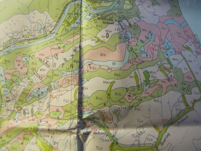
 My county soil survey is an
ancient book with four maps stuck in a pocket inside the back
cover. The hardest part is locating your property on the soil
survey maps since they only include roads, houses from whenever the map
was produced (1951 in my case), and large rivers and streams. I
did this the easy way by photographing the relevant section of the map
and then scaling it in the Gimp until the shape of the nearby river fit
with the same river curve on my aerial photo. Since I had the
boundaries as a separate layer in my map file, I could soon see which
soil types were found on the property and how they related to the one
cleared field (the irregularly shaped blob in the northwest corner of
the image above).
My county soil survey is an
ancient book with four maps stuck in a pocket inside the back
cover. The hardest part is locating your property on the soil
survey maps since they only include roads, houses from whenever the map
was produced (1951 in my case), and large rivers and streams. I
did this the easy way by photographing the relevant section of the map
and then scaling it in the Gimp until the shape of the nearby river fit
with the same river curve on my aerial photo. Since I had the
boundaries as a separate layer in my map file, I could soon see which
soil types were found on the property and how they related to the one
cleared field (the irregularly shaped blob in the northwest corner of
the image above).
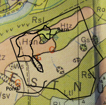
There's a key on the
side of the soil map that helps decipher the odd codes on the soil
survey. We live in a karst region, so there are lots of sinkholes
(the ovals with pointy teeth), and people have farmed our hilly land
too hard so there are gullys (red Gs). The other letters on the
map refer to the soil type: Hsn for the pink zone that includes most of
the current field, Ws for the paler area south of that, and so forth.
In our soil survey,
there's a separate fold out sheet of paper that turns the soil codes
into real words, then you can look up that soil type in the book to
learn much more about it. Here's what I discovered about the
cultivated areas on the property shown above:
|
|
Soil type |
Slope range |
Internal drainage |
Parent material |
Productivity and class |
Acres per animal unit |
|
Hsn |
Hagerstown silt loam; Rolling phase |
8-15 |
Medium |
Residual material from weathered limestone |
High; First |
1.5-2.4 |
|
RoL |
Rolling stony land (limestone material) |
3-30 |
Medium to slow |
|
Medium to moderately high; Fourth |
4.0-5.8 |
|
Htz |
Hagerstown stony silt loam; Steep phase |
15-60 |
Medium |
Residual material from weathered limestone |
Medium; Fourth |
2.3-3.3 |
|
Ws |
Westmoreland silt loam |
30-60 |
Medium |
Residual material from weathered limestone and shale mixed |
Medium; Fourth |
2.4-3.8 |
Of course, all of this
mapping should be taken with a grain of salt --- or rather, a shovel
and a day on the ground. For all I know, the prime topsoil in the
Hagerstown silt loam has all eroded away, but if it hasn't, that area
is clearly the best spot for vegetable gardening, while the poorer soil
on the east and south ends of the field could use some soil-improving
grazing. Taking a look at the real state of the ground is a good
thing to add to the list for a site visit!

Or explore more posts by date or by subject.
About us: Anna Hess and Mark Hamilton spent over a decade living self-sufficiently in the mountains of Virginia before moving north to start over from scratch in the foothills of Ohio. They've experimented with permaculture, no-till gardening, trailersteading, home-based microbusinesses and much more, writing about their adventures in both blogs and books.
Want to be notified when new comments are posted on this page? Click on the RSS button after you add a comment to subscribe to the comment feed, or simply check the box beside "email replies to me" while writing your comment.
Mom --- Where it says "internal drainage", you can see how likely a certain patch of soil is to get swampy. If you combine that with a topo map showing that there's a stream there or nearby, you can get a good estimate of where swamps might be. I'll be posting about how to find topo maps of your region next week.
You can find geological information on different maps too. Around here, limestone = caves.